About 3:23 • no narration • every source credited on screen • numbers as of 9:30 AM PT, Sunday, October 18, 2026
The Cooley Fire, west of Cloverdale in Mendocino County, is now the largest and least contained fire we are tracking: CAL FIRE (updated 7:12 AM) lists it at 731 acres and 5% contained, cause under investigation. Firefighters worked overnight with night-flying helicopters supporting strategic firing operations; more crews and equipment arrive today, but steep, rugged terrain and limited road access make parts of the fire hard to reach. CAL FIRE lists no evacuation orders or warnings (CAL FIRE). The Norte Fire (San Clemente / San Juan Capistrano) is holding at 570 acres and 25% contained. All evacuation orders were lifted at 6 PM Saturday, and OCFA’s damage assessment now counts seven homes damaged or destroyed, up from six. Via La Mirada north of Esperanza stays closed to vehicles and the burn scar is closed until further notice; today crews begin suppression repair to reduce erosion (OCFA, 8:28 AM). The National Weather Service says Santa Ana winds are diminishing, with rain forecast for Wednesday and Thursday.

Cooley Fire: details (click to open)
- Where and when: Elkhorn Road and Cooley Ranch Road, west of Cloverdale, Mendocino County, near the Sonoma County line. Started Friday, Oct. 16, at 5:05 PM. CAL FIRE Mendocino Unit is in charge (CAL FIRE, last updated 7:12 AM Sunday).
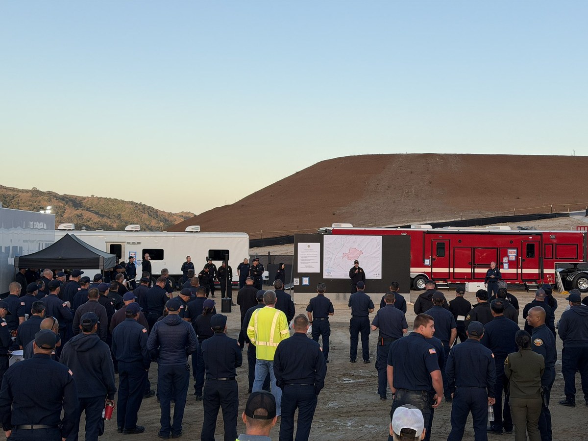
- Overnight (CAL FIRE, 6:59 AM): suppression continued with night-flying helicopters supporting strategic firing operations. More firefighting resources continue to arrive and will go to the fireline. Steep, rugged terrain and limited road access make it difficult to reach some areas.
- Acreage: CAL FIRE’s page shows 40 acres Friday night, 1,000 acres Saturday at 11:10 AM, then 558 acres at 12:33 PM “due to more accurate mapping,” then 731 acres at 5:11 PM. Containment 5% since Saturday 1:14 PM.
- Cause: under investigation (CAL FIRE). The Press Democrat reported Friday evening that CAL FIRE Battalion Chief Marshall Turbeville said crews were called to assist a property owner after a prescribed burn on private land spotted over a road and crossed its boundary, and that he said it posed no risk to the public (Press Democrat). We are not assigning blame; the investigation is not complete.
- Evacuations: none listed on CAL FIRE’s page. Wine Country Gazette’s alert tracker said Genasys Protect showed no Mendocino County zone other than normal at 5:58 AM Sunday and the sheriff had posted no alerts in 24 hours (Wine Country Gazette). Check your zone at MendoReady.
- Injuries and structures: none reported as of Saturday afternoon (SFGate: no injuries, no structures threatened).
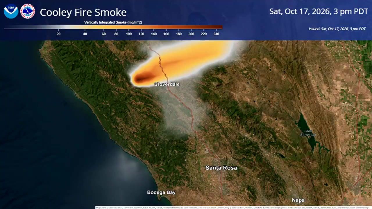
- Smoke: the Bay Area Air District has an air-quality advisory for Sonoma, Napa and Marin Counties; CAL FIRE says smoke may be visible across Lake, Mendocino, Napa and Sonoma Counties. NWS Bay Area posted a smoke forecast animation, shown at slow speed in the video (NWS Bay Area; Bay Area Air District).
- Weather: NWS Eureka (1:27 AM): stronger northwest winds Sunday afternoon over ridges and through terrain gaps, then improving humidity; showers possible from Monday, with the best chance of wetting rain, up to 45%, over southern Mendocino and Lake Counties later in the week.
Norte Fire: what changed since Saturday (click to open)
- Homes: OCFA’s damage assessment teams confirmed seven homes damaged or destroyed (OCFA post, Sat. 7:28 PM). Saturday morning’s count was six.
- Evacuations: OCFA and the OC Sheriff lifted the remaining orders (San Juan Capistrano Zones 4, 5 and 10; San Clemente Zone 12) at 6 PM Saturday; the OC Sheriff page says no Norte Fire evacuation orders remain. Via La Mirada stays closed to vehicles north of Esperanza, and the burn scar is closed until further notice (OC Sheriff; CAL FIRE).
- Acres and containment: 570 acres, 25% contained (5% Saturday morning). OCFA says the fire stayed within its established footprint.
- Sunday plan (OCFA, 8:28 AM): crews will work to increase containment and begin suppression repair, repairing areas disturbed by firefighting to help reduce erosion.
- Cause: under investigation. Information hotline: 714-628-7085. Media line: 949-447-1627.
- Returning home: the OC Sheriff page asks residents to use caution, follow road closures, avoid stirring up ash, and check water advisories (Santa Margarita Water District).
California fires now (click to open)
CAL FIRE incident list, checked 9:30 AM PT, Sunday, October 18, 2026. The Norte, Henderson, Bryson and Peak fires are listed as another agency’s incident. Every page lists the cause as under investigation. The Dome Fire (Mariposa County), on Saturday’s list, no longer appears among active incidents.
| Fire | County | Started | Acres | Contained | Saturday 9:45 AM |
|---|---|---|---|---|---|
| Timber Fire | Monterey | Aug. 8 | 25,352 | 97% | 97% |
| Henderson Fire | San Diego | Oct. 15 | 3,160 | 65% | 35% (3,132 acres) |
| Cooley Fire | Mendocino | Oct. 16 | 731 | 5% | 0% (40 acres) |
| Norte Fire | Orange | Oct. 16 | 570 | 25% | 5% |
| Cyrus Fire | Kern | Oct. 9 | 543 | 96% | 95% |
| Bryson Fire | Los Angeles | Oct. 15 | 146 | 68% | 52% (147 acres) |
| Surgone Fire | Humboldt | Oct. 11 | 64 | 75% | 75% |
| Peak Fire | Los Angeles | Oct. 15 | 43 | 41% | 41% |
| Marshall Fire | Humboldt | Oct. 11 | 12 | 85% | 85% |
- Henderson Fire (Camp Pendleton): 65% contained (CAL FIRE, 7:50 AM); crews are in mop-up, with weather expected to turn more favorable (higher humidity, onshore winds). One structure destroyed; 485 personnel assigned (CAL FIRE).
- Bryson Fire (Malibu): evacuation orders and warnings were lifted Saturday evening, with two zones left as advisories; CBS LA and ABC7 report no structures damaged, minor injuries to crews and all roads reopened (CBS LA).
Fire weather (click to open)
- NWS San Diego (5:04 AM Sunday): Santa Ana winds are diminishing; easterly gusts of 20 to 35 mph continue on coastal slopes and through passes this morning. Weak onshore flow returns today with some cooling, though highs stay 4 to 10 degrees above normal. Widespread light to moderate rain is expected late Wednesday into Thursday; the product lists no Red Flag Warning (NWS).
- NWS Los Angeles/Oxnard (7:16 AM): a 4 to 5 day cool-down begins; one last morning of offshore winds in the mountains and canyons. Widespread rain is likely Wednesday and Thursday with a slight chance of thunderstorms; flood and debris-flow concerns would be enhanced near recent burn scars (NWS).
- NWS Eureka (1:27 AM): see the Cooley Fire section (NWS). Forecasts change.
If you are in the area (click to open)
- Official sources: CAL FIRE Cooley Fire • CAL FIRE Norte Fire • OC Sheriff Norte Fire page • OCFA on X • MendoReady • NWS San Diego.
- Evacuation order means leave now. In an emergency call 911. Norte Fire hotline: 714-628-7085.
Clips, credits and transcript (click to open)
| Time | Source | Date • place | Speaker | Length | Type | Link |
|---|---|---|---|---|---|---|
| 0:20–0:30 | National Weather Service Bay Area | Cooley Fire smoke forecast, Sat. Oct. 17, 2 PM to Sun. Oct. 18, 3 AM PDT (posted Sat. 3:36 PM PT) | None (animation, slowed) | 10 s | U.S. government | Original |
| 0:40–0:46 | Orange County Fire Authority | Photo posted Sun. Oct. 18, 8:28 AM PT | None (photo) | 6 s | Official | Original |
| 0:46–1:11 | Orange County Fire Authority | Posted Sat. Oct. 17, 2026, 6:04 PM PT • Norte Fire repopulation briefing | TJ McGovern, OCFA Fire Chief | 25 s | Official | Original |
| 1:11–1:43 | Orange County Fire Authority | Same briefing | Capt. Justin Chevalier, OC Sheriff’s Department (chief of police services, San Clemente) | 32 s | Official | Original |
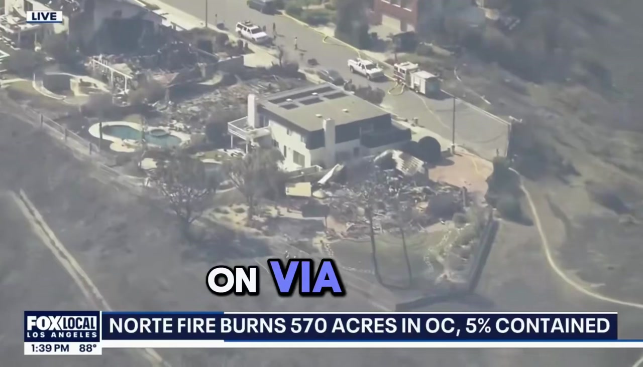
| 1:43–2:05 | FOX LA (photographer Justin O’Brien, on X) | Norte Fire aerial live hit; on-screen clock 1:39 PM; posted Sat. Oct. 17, 11:15 PM PT | O’Brien, FOX LA aerial photographer | 22 s | Social video, not independently verified | Original |
| 2:37–3:08 | FOX Weather | Posted Sun. Oct. 18, 2026, 4:00 AM PT • forecast portion only | FOX Weather meteorologist (not named in the post) | 31 s | Outlet | Original |
Transcript (our transcription)
| Time | Speaker | Words |
|---|---|---|
| 0:46 | OCFA Fire Chief TJ McGovern | Good evening. I’m TJ McGovern, Fire Chief for the Orange County Fire Authority. And my partner and I, we have positive updates that we’re going to give all of you. So first of all, due to the work that the firefighters and law enforcement partners did yesterday, last evening and today, we have increased our containment to 25%, and the fire is still staying within the footprint that was established last night. On screen: 25% contained |
| 1:11 | Capt. Justin Chevalier, OC Sheriff’s Department | Good evening. I’m Captain Justin Chevalier with the Orange County Sheriff’s Department. I currently serve as the chief of police services for the city of San Clemente. We are pleased to announce the lifting of the evacuation zones in San Juan Capistrano and San Clemente. In San Juan Capistrano, that includes zones four, five and 10. In San Clemente, that includes zone 12. This is with the exception of Via La Mirada, north of Calle Esperanza. Orange County Fire Authority is still going to be working on that neighborhood, so please remain outside of that area. The additional closure will include the burn scar area, that is Patriot Trail [as heard]. On screen: Evacuation zones lifted |
| 1:43 | Justin O’Brien, FOX LA | The start of this fire is still unknown at this stage. It’s just so devastating to see the destruction here on Via La Mirada, which was one of the streets heavily impacted by the Norte Fire. And it’s again just how indiscriminate fire and wildfires are, that house next door untouched, the houses either side of it burnt to the ground. On screen: Via La Mirada |
| 2:37 | FOX Weather meteorologist | Also, it’s the overnight hours, so the winds aren’t kicking around too much right now, but the forecast does call for a really dry stretch through about Tuesday. Our saving grace comes by the time we get to Wednesday and on Thursday. We could not be more excited about this, right? Wednesday and Thursday, anticipating showers, perhaps even a couple of thunderstorms. This is welcome news for our friends and, of course, our family members on the West Coast. On screen: Rain: Wed. and Thu. |
No narration: the voices are the officials, reporter and meteorologist in the clips. We used only the forecast portion of the FOX Weather segment; its fire figures (posted about 4 AM) are older than CAL FIRE’s morning numbers shown above. The FOX LA clip’s on-screen graphic (“5% contained”) is from Saturday afternoon.
Sources and cautions
- Figures are from CAL FIRE incident pages and list (Cooley 7:12 AM, Henderson 8:01 AM, Norte last updated Sat. 10:14 PM), OCFA posts (Sat. 7:28 PM and Sun. 8:28 AM), the OC Sheriff page (Sat. 6 PM), and NWS forecast discussions, read between 9:10 and 9:30 AM PT Sunday, October 18, 2026. Numbers change.
- CAL FIRE’s Cooley page lists the cause as under investigation. The prescribed-burn account is a Friday news report of a CAL FIRE battalion chief’s statement, not a finding.
- Press Democrat, SFGate, Wine Country Gazette and the Bay Area Air District are cited for the items marked above. Photos: OCFA; NWS (U.S. government work); stills from the OCFA and FOX LA videos.
Credit on screen for every clip. The FOX LA and FOX Weather material is social-media video we have not independently verified.
Clips used under fair use for news reporting and commentary. All footage © its respective owners. Credits are in “Clips, credits and transcript” above.